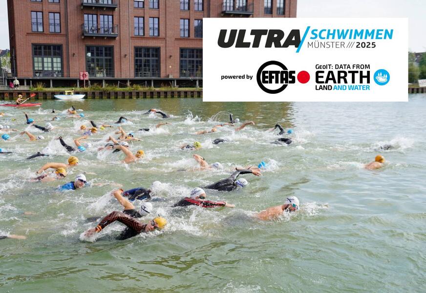
Ultra Swim 2025 – powered by EFTAS!

EventsTeam
Share this post:
Contact person
A sporting highlight, right on our doorstep in Münster harbour.

Anyone who has ever swum ten kilometres (or even just one) knows full well: it takes staying power, planning and a clear focus on the goal! These are qualities that also characterise our global GeoIT projects: for Earth observation of land and water areas, we need perseverance, good preparation and the will to make a difference!

Against the backdrop of Münster harbour, the ‘Ultra Swim’ took place on Saturday (30 August 2025). With distances ranging from 1 to 10 kilometres, there was something for everyone, whether you were taking part as a recreational swimmer or tackling an ambitious long-distance challenge. And those who swim with fins weren’t left out either.

We support ‘Tri Finish Münster e. V.’ and the ‘Ultra Swim 2025’ as the main sponsor because commitment is important to us – and not just when it comes to geodata.

The circuit ran entirely within the harbour basin, meaning the races could be watched up close throughout the day. Our managing director, Olaf Büscher, was also there, cheering on the swimmers from the harbour edge: “You can really feel first-hand the dedication that goes into these outstanding performances. But the relaxed atmosphere is great too – and at the same time, you can sense sporting ambition everywhere! A truly wonderful event that we’ll be happy to support again next year!”

A huge shout-out to everyone who took part in the water today and to Tri Finish Münster, who organised the event!

All the information about the competition can be found here:
www.ultraschwimmen.de

Foto: Tri Finish Münster e. V. / Martin Epkenhans

Share this post:

Similar posts

Ultraschwimmen 2026: A New Perspective at the Münster Harbor!

26.08.2026

This Saturday, for a change, we won’t be looking down at the water from above. That’s because the “Ultraschwimmen Münster 2026” will once again be taking place at the city harbor!

EventsTeam

Running with burning soles at the Campus Run!

29.06.2026

Our running team challenged the heat at the Leonardo Campus Run last week.

Team

ESA-ESRIN INSIGHT 2026: EFTAS presents GIGASAR

20.05.2026

New approaches to combining SAR monitoring, AI and BIM met great interest in Frascati.

Events

The European Conference for Biodiversity Monitoring

08.05.2026

In Montpellier EMBAL was part of the BioMonWeek 2026!In Montpellier war EMBAL Teil der BioMonWeek 2026!

Environment & NatureEventsGeospatial Data, Analysis & Acquisition

Poster award for GIGASAR

07.05.2026

Award for the innovative integration of SAR, BIM, and geospatial data for infrastructure movement analysis.

City & Transport

Satellite data for sustainable decisions

24.03.2026

EFTAS at the SustainableSolutionsMatch 2026

Environment & NatureEventsGeoIT-ServicesGeospatial Data, Analysis & Acquisition

Focus on AI-supported forest analysis

18.03.2026

EFTAS auf der SmartForest 2026

Agriculture & ForestryEventsGeoIT-ServicesGeospatial Data, Analysis & AcquisitionResearch & Consulting

Cop4ALL-DE is part of the German Government’s 6th “Geo-Fortschrittsbericht” (Geo Progress Report).

13.02.2026

The report outlines developments in the field of geoinformation.

GeoIT-ServicesGeospatial Data, Analysis & AcquisitionResearch & Consulting

Precise green space monitoring for climate-resilient cities

10.02.2026

EFTAS demonstrates an integrated approach combining remote sensing, AI and close-range photogrammetry

City & TransportDownloadGeospatial Data, Analysis & Acquisition

GIGASAR: The trend topic ‘Precise infrastructure monitoring’

29.01.2026

New opportunities through the fusion of BIM and SAR data in ESA project.

City & TransportGeoIT-ServicesGeospatial Data, Analysis & AcquisitionMining & Geo-ResourcesProjectsResearch & Consulting

Subscribe to our newsletter.

Subscribe to our newsletter.









