Precise green space monitoring for climate-resilient cities

City & TransportDownloadGeospatial Data, Analysis & Acquisition
Share this post:
Contact person

Cities face the challenge of managing green spaces efficiently whilst making them climate-resilient. This requires up-to-date, reliable data. EFTAS has advanced its workflows for the digital mapping of urban green spaces and demonstrates how remote sensing, AI-supported analysis and close-range photogrammetry work together seamlessly.

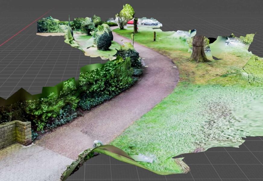
We use high-resolution aerial imagery and precise 3D stereo mapping to create a comprehensive digital representation of urban green spaces. Where this form of analysis reaches its limits, we supplement it with smartphone-based close-range photogrammetry.

Using short video sequences, we capture hidden or hard-to-access areas and use them to generate georeferenced 3D models. In this way, for example, sections of paths, playground equipment or benches hidden beneath dense tree canopies become visible. Information that previously could only be obtained through time-consuming field surveys can now be captured more efficiently and with greater data depth.

A detailed technical article on these developments has been published in the latest issue of Business Geomatics.

The article can be downloaded here (Source: Business Geomatics Issue 4/2025):

Download our article on green space monitoring
Share this post:

Similar posts

Ultraschwimmen 2026: A New Perspective at the Münster Harbor!

26.08.2026

This Saturday, for a change, we won’t be looking down at the water from above. That’s because the “Ultraschwimmen Münster 2026” will once again be taking place at the city harbor!

EventsTeam

Running with burning soles at the Campus Run!

29.06.2026

Our running team challenged the heat at the Leonardo Campus Run last week.

Team

ESA-ESRIN INSIGHT 2026: EFTAS presents GIGASAR

20.05.2026

New approaches to combining SAR monitoring, AI and BIM met great interest in Frascati.

Events

The European Conference for Biodiversity Monitoring

08.05.2026

In Montpellier EMBAL was part of the BioMonWeek 2026!In Montpellier war EMBAL Teil der BioMonWeek 2026!

Environment & NatureEventsGeospatial Data, Analysis & Acquisition

Poster award for GIGASAR

07.05.2026

Award for the innovative integration of SAR, BIM, and geospatial data for infrastructure movement analysis.

City & Transport

Satellite data for sustainable decisions

24.03.2026

EFTAS at the SustainableSolutionsMatch 2026

Environment & NatureEventsGeoIT-ServicesGeospatial Data, Analysis & Acquisition

Focus on AI-supported forest analysis

18.03.2026

EFTAS auf der SmartForest 2026

Agriculture & ForestryEventsGeoIT-ServicesGeospatial Data, Analysis & AcquisitionResearch & Consulting

Cop4ALL-DE is part of the German Government’s 6th “Geo-Fortschrittsbericht” (Geo Progress Report).

13.02.2026

The report outlines developments in the field of geoinformation.

GeoIT-ServicesGeospatial Data, Analysis & AcquisitionResearch & Consulting

GIGASAR: The trend topic ‘Precise infrastructure monitoring’

29.01.2026

New opportunities through the fusion of BIM and SAR data in ESA project.

City & TransportGeoIT-ServicesGeospatial Data, Analysis & AcquisitionMining & Geo-ResourcesProjectsResearch & Consulting

Climate Alliance visits EFTAS

10.12.2025

New impulses for climate protection – a focus on heat pumps.

Environment & NatureTeam

Subscribe to our newsletter.

Subscribe to our newsletter.









